For Operating Accessories - Click Here
DXCC is copyright ARRL and its use here is printed with permission of the ARRL.
TIME LINKS UTC
NOW IS
When Asked What The Time
Was;
Yogi Berra Replied "You Mean Right Now?"
Hams Reply -- You Mean Right Here Or UTC?
PROGRAMS TO SET YOUR COMPUTER TIME
About Time -- Sets your PC Clock or Server
AtomTime -- Sets ur Clock to world standards
SocketWatch -- Keep your PC clock accurate with the ultimate time client for Windows.
Atomic Clock Sync utility -- set your local PC time with the US Atomic Clock
---------------------------------------------------------------------------------------
WEB PAGES ABOUT OR GIVING TIME
World Time Zone .com -- Several WOW presentations
World Clock - Time Zones -- Local Time of many cities around the world.
HamClock -- Desk Top program for Time in the All DXCC Prefixes -- A Real Winner and its Free!! From Mike, DF1ZN
Official US Time -- Precise UTC Time -- On Line - From Department of Commerce and NIST
U.S. Naval Observatory Master Clock. -- Precise UTC Time -- On Line
Beacon Wizard -- Track the NCDXF Beacons and Sets your PC Clock to world standards
NIST Java UTC Clock -- Precise UTC Time -- On Line
World Time Zone Map -- From The U.S. Naval Observatory
UTC/GMT Time Conversions To Local Time
Sunrise/Sunset, Gray line and UTC Time From HAB Software, Hamburg, Germany.
Sunrise/Sunset -- By City -- Moontimes also - From The U.S. Naval Observatory
![]() Time And Frequency Stations
-- WW Precise UTC Time and Frequencies
Time And Frequency Stations
-- WW Precise UTC Time and Frequencies
Standard ITU Phonetic Alphabet - Sometimes referred to as NATO Phonetics
A Zillion Phonetic Alphabets.
-- Alpha, Baker, Cocoa, Dog.
DXers Phonetics
--By AC6V - Unofficial Of Course!
Phonetic Alphabets
-- Historic, English and others -- via J.W.Alcorn - VK2JWA
Language Translator
-- Great DX Tool -- From SYSTRAN�
Language Translator
-- Great DX Tool -- From FreeTranslation.com
![]() Morse Code Pages
--Ultimate CW Pages
Morse Code Pages
--Ultimate CW Pages
Morse Code Trainers
--Many To Choose From
![]()
AC6V's Guide To Ham Q-Signals Commonly Used On VHF Repeaters
More Q-Signals For Hams -- Washington State Net
MEGA Q-Signals List -- Edition 1994, 1998 --- VERY LONG NOTE: Most of these are not used by Amateurs. Many for Navigation, Aviation, Marine, etc -- From Ralf D. Kloth - DL4T
The Missing Q-Signals -- Just For Fun
![]() QN-Signals.
-- For Net Use Only
QN-Signals.
-- For Net Use Only
![]()
![]() Part 97
-- From The ARRL
Part 97
-- From The ARRL
![]() US Third-Party Traffic Agreements
From The ARRL
US Third-Party Traffic Agreements
From The ARRL
Gray Line Program -- From Alex Shovkoplyas, ex UR5EMI (now in VE3)
Grey Line Map -- Color greyline map that automatically refreshes every five minutes -- from DX.QSL.NET
Grey Line Map -- by John Walker (Fourmilab)
DX View -- FreeWare. Find heading, country, distance, zone info from callsign prefix --- Includes Maps, Greyline and More. An absolute MUST SEE
SR/SS Enhancement and Grayline Propagation -- From N4KG
![]()
Graphical
traffic log Version 2.2.2 -- From Philippe F1TPL -- Locators
displayed on maps, DXCC displayed
on map, French department on map,
Traffic log, Contest
and report to EDI format, Audio caller, Statistics, graphics, Web
cluster
DX Atlas 2.24 By VE3NEA Has menu that allows you to type in a grid square number and the program places a cursor on the map presentation allowing you to determine the US state or country/province. Also gives distance, bearing, and prefixes.
Artsci has a publication that although it is a repeater guide (excellent), it has a map of all USA states and the grid squares within that state. The map extends slightly beyond the state borders, so one can see a grid square that encompasses 2 or more states.
![]() Grid
Square Finder -- From QRZ - Neat Program
Grid
Square Finder -- From QRZ - Neat Program
Grid Squares - WOW From WA5UUD Via The Six Meter World Wide DX Club
Grid Squares - WOW from ICOM -- Click on AMATEUR, then U.S. Grid Square Map (470 KB PDF)
Grid Squares -- From the ARRL Web -- on-line grid-square calculator. Grid-square calculator program for your computer. By hand, as explained in the QST Lab Notes PDF file
Grid Square Calculator -- Find Grid Squares By Long/Lat or find Long/Lat from Grid Squares --- From AMSAT
Your Grid Square can be found at QRZ.COM under Detailed Info. Not as exact as the AMSAT method above.
INTERNET
HAM ATLAS - From Darek
SP6NVK - complete
information on all
337 DXCC Entities, containing over 3000 pictures and over 1100 maps.
Result Of 4 Years Of Work - WOW.![]() DX FIELD
REFERENCE - FROM NIFTY ACCESSORIES
DX FIELD
REFERENCE - FROM NIFTY ACCESSORIES
Radio Amateurs World Atlas Book - From DARC Via The ARRL-- With CQ Zones and Prefixes
DX ATLAS - Great Atlas With Prefixes, Zones, Sun/Dark zones from VE3NEA
Ultimate DX World Map� wall map -- New From Millennia Arts
HAM MAPS A BUNCH WITH PREFIXES -FreeBees
FREEBEES
Map mash-up of ham licenses in the U.S. -- From KE6UZ, find map location of Hams by callsign, find Hams and Ham populations by State or Zip code!
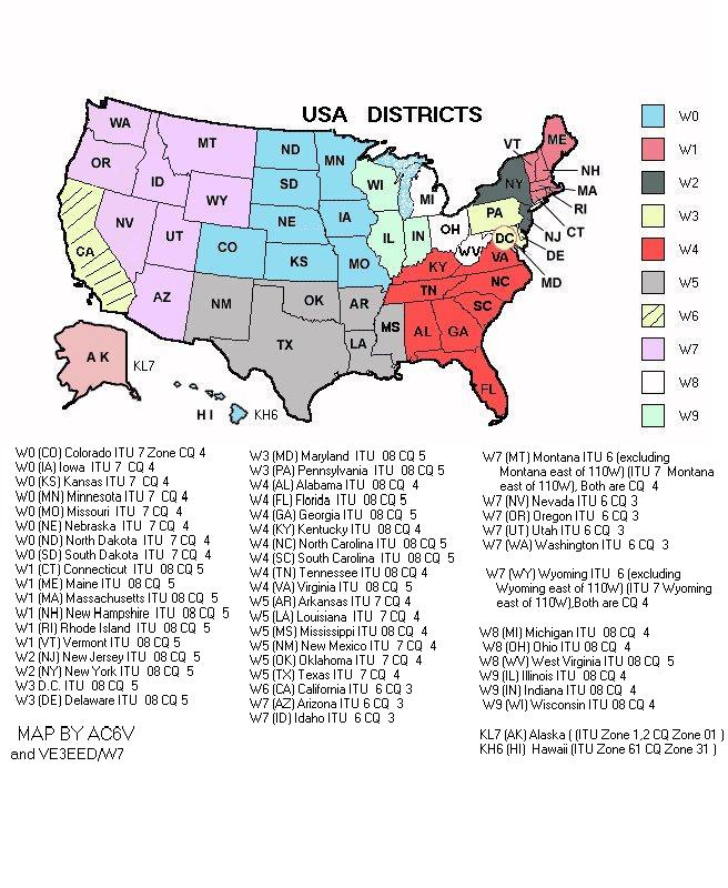
USA District Map -- From The ARRL
WAS Map For Tracking (coloring in) Worked All States
USA District Map -- By AC6V
USA District Map -- From Jeanne K1MOM
Graphical traffic log Version 2.2.2 -- From Philippe F1TPL -- Locators displayed on maps, DXCC displayed on map, French department on map, Traffic log, Contest and report to EDI format, Audio caller, Statistics, graphics, Web cluster
Ham Map of the World with prefixes -- From Allan, VK2CA
Ham Maps -- World Wide With Districts From SP8DA - New Additions -- Over 43 Ham Maps
Ham Maps -- AT LAST -- On Line -- A great set of Ham maps with prefixes -- see PREFIX ELMER
Ham Maps -- Worked All Continents WAC - From Nomrax
Ham Maps -- CQ Zones From Nomrax
CQ Zone Map From EI8IC
Ham Maps -- ITU Zones From Nomrax
Ham Maps -- ITU Regions From Nomrax
ITU Zone Map --A GIF From NEXUS-IBA
ARM - Amateur Radio Maps v 1.3 -- Must Download but a goodie!!
CIA FactBook -- Great Source of DXCC Country Maps & Facts
World Atlas.com -- Online World Atlas main page
World Atlas.com -- Islands Of The World
1 Up Travel.com -- World Atlas
Great Maps -- From Univ Of Texas -- Don't miss this one - covers the World with Long/Lats
TopoZone Maps -- Gives long, Lat, Elavation & Detailed Maps
Radio Line of Sight Plot Server
GcmWin - A program to make Great Circle Maps -- Via SM3GS Online Map Creation using AZ_PROJ v1.1.6 Great Circle Maps
Geodetic II -- Distance/Bearing Finder - From Klaus-Dieter Scholz
Great Circle calculations --GCGC by Ron McConnell W2IOL
Great Circle Maps - azprj104.zip program - For any point on the earth.
AZIWORLD This program is a generator of coloured azimuth world maps centered on any terrestrial position. From G. RIVAT F6DQM
Formulae For Calculating Great Circle Heading and Distance Information
![]()
 BEAM HEADINGS - DISTANCE BEARING
Amateur Radio ADF Is Back -- Highly Recommended.
DXCC Country List / Beam Headings -- From North Jersey DX Association
Distance and Bearing Finder. -- Enter 2 cities. Shows Distance, Beam Headings and maps -- By Bali Online
Beam Headings & Distance Excel
Spreadsheet -- In zip form from K7NO
Beam Headings
to DXCC Countries From The North Jersey DX Association
KawAZ is a Azimuth Angle Calculation Program for the Radio Amateur
DX View1.1.5 -- FreeWare. Find heading, country, distance, zone info from callsign prefix --- Includes Maps, Greyline and More. An absolute MUST SEE
Beam DX -- free software for radio amateurs or radio listeners. Allows to point an antenna towards an azimuth, a locator, an international prefix or any other geographical position on Earth predefined by its latitude and its longitude. Includes the DXCC list with their relevant geographical positions. From G. RIVAT F6DQM
QTH Locator -- By Klaus Evers's, DL3BAK -- Find Distance/Bearing and grid squares -- A Must See
Beam Headings By Using W6EL's
Propagation Program
GcmWin
- A program to make Great Circle Maps -- Via SM3GS
Geodetic II
-- Distance/Bearing Finder - From Klaus-Dieter Scholz
GcmWin
- A program to make Great Circle Maps -- Via SM3GS
Geodetic II
-- Distance/Bearing Finder - From Klaus-Dieter Scholz
Great Circle calculations -- -GCGC by Ron McConnell W2IOL.
Great Circle Maps - azprj104.zip program
- For any point on the earth.
Formulae For Calculating Great Circle Heading and Distance Information
Also see DX and Contest Software
Calculating
the Distance To The Horizon
Magnetic Declination/Variation
Map -- From The Compass Store
WORLD LATITUDES AND LONGITUDES
USA Latitude/Longitude Position Finder
-- Map Based Page to identify the latitude and longitude position of any point within the United States.
Formulae For Calculating Great Circle Heading and Distance Information
All About Compasses --
From The Compass Store
Determining declination from magnetic north
-- From The Compass Store
Zip Code Finder
-- From The Horse's Mouth
Zip & Area Code Finder
-- Click On "New General Combined Lookup" --- Zip/Area to County/City & Vice versa -- From Jay Computer Services
National Address Server
-- Enter U.S. postal address -- gives zip code, map, and a Postscript or a GIF file of the address for printing.
Geography links
GCGC great circle (ellipsoid), lat/long/grid, MUF, miles/Watt, DX database DOS
Command line calculator. Note: original site no longer live. Link goes to site page archive.
Online
Map Creation using AZ_PROJ v1.1.6 Great Circle Maps
Online
Map Creation using AZ_PROJ v1.1.6 Great Circle Maps
![]()
![]()
![]()
![]()
Many Thanks to W2IOL Ron McConnell
For The Geography Links.
28 mar 2003
Great Circle Bearing and Distance Calculator (Web's Best) http://www.indo.com/distance
World & USA: Mapblast (lat/long now hidden in URL) http://www.mapblast.com
World & USA: Maporama, Address to Lat/Long & Map http://www.maporama.com/share/
Worldwide Country City/Town Database (USGS + NIMA +...)
USA Geographical Locator: Montana State Univ. (Many maps...) http://www.esg.montana.edu/gl/
USA Latitude/Longitude Position Finder Map, 9-Step Zoom (Juggling Information
Service web site?) http://www.juggling.org/bin/un.cgi/map-find
Australia: Place Names (gazeteer) http://www.auslig.gov.au/mapping/names/natgaz.htm
Magnetic Declination/Variation vs. lat/lon, altitude, date http://www.ngdc.noaa.gov/cgi-bin/seg/gmag/fldsnth1.pl
Magnetic Declination/Variation on World Map: MAGVAR, under "Free
Stuff" http://www.pangolin.co.nz
Magnetic Declination/Variation World Map (PDF) http://www.thecompassstore.com/decvar.html
Royal Observatory at Greenwich: the beginning of the world Good information
http://www.rog.nmm.ac.uk
Bowditch American Practical Navigator web site http://www.irbs.com/bowditch
Ed Williams's Spherical Navigation Formulas with examples http://williams.best.vwh.net/avform.html
Ed Williams's Spheroidal Navigation Tutorial http://williams.best.vwh.net/ellipsoid/ellipsoid.html
US NGS Ellipsoidal Earth Models, Vincenty Inverse & Forward http://www.ngs.noaa.gov/PC_PROD/
Australian Mapping Agency: Geodosy reference, formulas, ... http://www.ga.gov.au/geodesy/
Omar Reis's Tecepe site with Celestial Navigation Tutorial & Navigator Light
3.0
http://www.tecepe.com.br/nav
Mentor Software's Worldwide Amateur Radio Call Prefix to Lat/Long/etc "Most
Complete". Note: original site no longer exists, link now goes to archive of page.
Marine Navigation Calculators -- several available. Note: original site is gone, link goes to archive of page.
GIS Data and Software, Free (Geocomm) http://www.geocomm.com
Astronomical and Numerical Software Codes: http://www.moshier.net
Historic Map Collection Online, David Rumsey "...6000 pieces, or about
150,000 individual cartographic items..." http://www.davidrumsey.com/
Historic & Current Maps, Collection Online: Univ. Texas http://www.lib.utexas.edu/maps
World Time Zone Map, CIA/PC http://geography.about.com/cs/timetimezones/index_2.htm
World Time Zones/Maps/Clocks http://www.worldtimezone.net
World Time Server: http://www.worldtimeserver.com/
--------------------------------
USA Street addresses to Lat/Long & Misc.
Latitude/Longitude Position Finder (9 zoom steps) [Juggling Info?]
http://www.juggling.org/bin/un.cgi/map-find
http://www.mapsonus.com
http://www.mapquest.com
or http://maps.yahoo.com
-----------------------------
United Kingdom (UK) Street Maps, Lat/Long, Postal Codes, Tel Codes, etc.
http://www.streetmap.co.uk
------------------------------
Azimuthal-Equidistant Projection Maps: (Great Circle Maps) GCMWIN Az-Eq maps,
SM3GSJ http://hem.passagen.se/sm3gsj/
----------------------------------
World Imagery Database (Photos from space) http://www.terraserver.microsoft.com
-------------------------------
Many Thanks to W2IOL Ron McConnell For The Geography Links.
28 mar 2003
![]()
Last Update: January 18, 2010